Monthly Archives: June 2011

Day 4: Alaska!

Day miles: 516
Trip miles: 2168
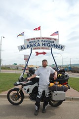
Teslin, BC to Tok, AK

A building trend of late mornings continued. I had breakfast at the cafe where I camped and took some time to upload photos to flickr over the unreliable wireless.

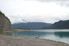
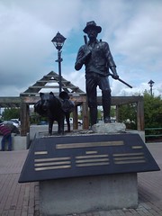
Nevertheless I got back on the road. I quickly reached Whitehorse, the capital of the Yukon Territories; a big city! The first since the start of the Alaskan Highway.

I struggled when leaving Seattle over what to wear for boots. I had a pair of military style fake leather boots, and my L.L. Bean boots with Goretex lining and Thinsulate insulation. I was tempted toward the “Bean boots” but a bit of nice weather made me take the lighter ones. This was a mistake, as I was soon waking up and riding in wet weather in 40 degree temperatures.

I had been on the lookout for a good outdoor clothing store, and in Whitehorse I finally found one: Coast Mountain Sports. This was like an L.L. Bean or REI, as opposed to a hunting outfitter like I had been finding so far along the way. I was able to find a pair of Goretex lined hiking boots here. While not perfect for riding because they had no ankle support, they were much warmer. I also picked up another upper layer and some merino wool glove liners to go inside the thicker motorcycle gloves I wear in the rain. This would all prove very useful later on.

When planning my trip, I came up with a handful of ideas as to what to do during the middle of my time off. One idea was to do some backpacking in the National Parks, so I brought along a lot of backpacking gear: a stove, pot, water filter, bear canister, etc. This turned out to be excessive, and I decided to ship home 35 pounds of it from Whitehorse. The weight wasn’t a problem but I was getting tired of moving around the bulk every night. I found a Mail Boxes Etc that claimed they could ship to the states, but once I had everything packed, they discovered they couldn’t ship personal items by ‘courier,’ which included UPS and Fedex. A customs problem perhaps? I don’t know, but my big box went home Canada Post. I don’t know if or when it will arrive.

I wandered around Whitehorse a bit, sipping a soy latte from Starbucks for kicks, laughing at the first annual Whitehorse naked bike ride, and their ensuing problems with the police. It was a nice sunny day, but I had a long way to go and soon got back on the road.

After dinner at another roadside truck stop/cafe, I passed through an area called Destruction Bay. It started sleeting as I arrived and in less than a mile I saw danger signs warning of heavy crosswinds, rocks in the road, and animals in the road. Unabated, I continued through and made it unscathed.

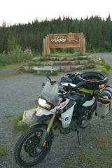
I eventually reached the border, where my Washington “Enhanced Drivers License” was picked up my the RFID scanners and I was let back home to the states pretty easily. The first sign was in the United States was something about the roads. The pavement at the border was fresh, but that wasn’t it. Perhaps the MUTCD specifies line painting in such a way that we become accustom to?

I pushed on late into the night and reached Tok, Alaska. Shortly thereafter I found a small park on Moon Lake and set up camp for the night. I was pleased to find a couple of float planes beached here. I grew up around them, and this trip is as much in memory of my father as it is for me. I made it to Alaska and it was just how we both hoped it would be.

Edit 2011-06-18: Cleanup up the post a bit.

Day 3: Alaska Highway

Day miles: 422
Trip miles: 1652
Tetsa River, BC to Teslin, BC

I woke up in a drizzle today, packed up and headed down the road. I soon began seeing signs for Tetsa River Outfitters and their “famous” cinnamon buns. Hungry and in search of coffee, I was sold right away. The camp ran on a generator but had a solar powered Trace system with a few strings of C&D batteries, which I recognized from my years working in telephone offices. When I asked about their origin, the proprietor came over to ask if I was familiar with the system at all as he was having problems with the inverter. Another patron and I looked it over, but the owner was pretty busy and we didn’t talk to him about it again. It seemed as though the former owners had passed away and he was struggling a bit to fill their shoes, but the food and coffee were good. Mostly I enjoyed the lifestyle that was communicated by the buildings and equipment. From the distance to anywhere, these folks clearly survived out here on their own ingenuity.

Canada has more road signs that are pictures rather than words compared to the United States. The best have been the wildlife road signs. I saw many more signs warning of wildlife than I saw actual wildlife. I wondered if Canada negotiates territory with animal herds, as I would often see a sign for moose, then one for horses, then another for moose. How do they negotiate their borders? Normally the signs for horses show the horse running or jumping, I can’t tell the difference, but then I saw one of a horse standing. Perhaps it was a sign for wild mules? Later I saw three signs in a few miles that had different size antlers and I was ashamed to have no idea what animal they were meant to represent.

Further down the road, I stopped for a late breakfast at Toad River lodge. I had an enjoyable long conversation over food with a couple traveling with their baby daughter from outside Toronto to Whitehorse, where she doing the Yukon River Quest from Whitehorse to Dawson City for some kind of charity.

Eventually the sun came out in time to have nice weather while passing Muncho Lake and appreciate its unique color. Back on the wildlife front, I was getting a little disappointed about not having seen any wildlife on the Alaskan Highway. Eventaully I started seeing Wood Bison. Then I saw an animal crossing the road up in the distance. When I passed where it crossed I looked in the woods and saw a wolf staring back. I have a fondness for wolves, so my disappointment was completely cured by this sight.

I spent the night at a campground on Teslin Lake at a truck stop. This provided some decent wireless access for uploading pictures and catching up on email, as well as having breakfast conveniently located nearby.

Day 2: Dawson Creek

Day miles: 597
Trip miles: 1230
Alexandria, BC to Tetsa River, BC

Shortly before I left Seattle, I found out that there were delays on the Stewart-Cassiar due to wildfire, so I decided that I would head to Dawson Creek so that I could ride the entirety of the Alaskan Highway. Dawson Creek is also sometimes called “Mile 0,” due to being the start of this highway. When I got to town, I started following signs for an information center. Along the way I stopped to take a photo of a Boston Pizza that had a banner up supporting the Vancouver Canucks over the Boston Bruins.

The information center was incredibly useful. I got a convenient list of services along the Alaskan Highway to stuff in the map pouch of my tank bag for easy reference. Services are far apart on the highway and you drive by nearly as many remains of stops that have gone out of business as you do open services. I also picked up a copy of the Milepost, an inch thick annual publication that details all of the highways in the northwest. Mile by mile information contained within tells you just about everything you could possibly want to know. I chatted with a couple of motorcyclists about our plans here in the parking lot, and got a picture of myself to commemorate the stop.

I stopped by an outdoor clothing store here and a bit further down in the road in search of an additional base layer. Unfortunately both of these places were focused on hunting and fishing. Not only could I not find a base layer in my size, almost everything was camouflage.

When I finally headed out down the highway, I was hit with pretty gusty wind. It is somewhat strange having to lean the bike to counter the wind and continue riding straight ahead. I was reminded of crabbing an airplane. Quite tired from the night before, I eventually I stopped at a rest area for a brief nap to get my wits back about me.

Late that night, I found a provincial park along the Tetsa River. Camping parks like this are much better when they are remote and you are far from the cities. Once the tent was up, bike unloaded and everything packed away from the bears, I got some much needed rest.

Day 1: BC99

Seattle, WA to Alexandria, BC
Day miles: 633
Total miles: 633

I left on a typical Seattle day: overcast and gloomy. I did not set a time to leave, but ended up on the road around 10:30am. Since I live south of downtown, this unfortunately meant that I hit morning traffic getting through the core. I am the type that often prefers the sensation of progress over actual progress when it comes to driving, so I got off Interstate 5 for a bit downtown and took surface streets past the usual choke points on the interstate.

The drive to the Canadian border was familiar and uneventful. Once at the border I was directed to park and go inside to provide my CAFC 909 for my shotgun. They wanted to match the serial number on the paperwork to the firearm on their own, so I sat inside for around a half hour waiting. When all was finished and I came outside one of the border agents was waiting to talk to me about my bike. As it turns out, she has an F800GS as well and we chatted for fifteen minutes about aftermarket accessories before I went on my way. All told, I had a great experience at the border.

Once in Canada, I set my GPS to take me through Vancouver to Whistler. Years ago I had driven BC 99 and my memory of it made me want to do it again on the motorcycle. This was a great decision. Once past Whistler, it is remote two lane mountain road, following a river most of the way. The only setback is that it seems that every RV rental comes with directions to come here as well. Fortunately the bike has plenty of power and I was able to whip around all the RVs within a minute of coming upon them.

My detour ended near Cache Creek where I had a nice dinner and caught up on the Canucks/Bruins game. I’ve kept my minor allegiance to the Bruins to myself while up here for my own safety.

I had decided to ride the entire Alaskan (Alcan) Highway, so I headed for Dawson Creek, BC from here. BC99 had plenty of provincial parks along the way, and I was hoping to find one for the night now. Unfortunately I seemed to be in a dry spot for parks, so I unrolled my sleeping bag on the ground in a rest area alongside the highway for the night instead.

By the way, Spot made my name my messenger (tracker) unit. Being a less than creative chap, I named it “orange.” Because, it is. A couple people have thought that it says orange on the site so often because that is some kind of status of my device, like I am at Defcon 2 or something. This is not the case. Everything is green here!

Alaska Motorcycle Trip

Last year I bought my dream motorcycle, a BMW F800GS.

While I was growing up my father occasionally spoke of wanting to go to Alaska some day. He rarely had a lot to say, so this stuck with me. As I grew older, his health continued to deteriorate, primarily due to smoking, drinking, and a lack of getting out. By my twenties he was out of work on long-term medical disability and didn’t leave the house much.

Two months ago he passed away, at only 58.

So I leave today for a three week self-supported motorcycle trip to Canada and Alaska from Seattle, Washington. There is never going to be a better time to achieve your goals then the present.

I believe the F800GS to be the ideal blend of existing BMW Adventure motorcycles; bikes designed to get off the beaten path anywhere in the world. It lies between their smaller single cylinder “thumpers” like the original F650GS and the larger two cylinder “boxers” such as the R1200GS that Ewan McGregor and Charley Boorman ride in the Long Way Around TV series and sequels.

My plan is to take the Alcan highway up. Once in Alaska I will ride the Dalton Highway north past the Arctic Circle to Deadhorse. The Dalton connects the oil industry in Prudhoe Bay on the Arctic Ocean to the rest of Alaska. Over four hundred miles of dirt road with only a couple stops with services (with populations of 25 and under), the route is remote.

I have left the middle of my trip open. By the time I will have returned to Fairbanks I will have ridden over 3000 miles and I will evaluate then what is next then. Obviously I may be tired of riding, but once out in the great expanse I may just want to sit for a spell. Growing up I used to spend a lot of time at cabins in the North Maine Woods, mostly just sitting. One option is to ride back over to the Yukon Territories and ride Canadas sister route, the Dempster Highway. If I don’t feel like riding as much, I may get a charter plane into the trail-less and road-less Gates of The Arctic National Park. Time will tell.

Towards the end of my journey I plan to meet up with 175+ motorcycles in Dawson City, Yukon for the annual Dust To Dawson motorcycle gathering. Then 2000 miles home to Seattle.

I’m carrying all the typical supplies for backpacking. I have a change of tires as well. Not spare tires mind you, I’m doing so many miles I’ll need to change them. Besides, the bike currently rides on tires primarily meant for the street. Before the Dalton Highway, I’ll swap on a set of knobby tires for the dirt roads. Because it can be hundreds of miles between service stations on some of the routes I will be traveling, I’m carrying a 2 gallon Rotopax fuel tank. I will also be camping in remote wilderness, so I’m bringing along a 12 gauge shotgun.

I have a Spot GPS Tracker, so you can monitor my progress either on the Spot Adventures or directly on the Spot Website. When possible, there will be updates on Twitter, photos on Flickr, and posts here.